The earliest recorded accounts of property surveys are in Egypt, but it is assumed that the Babylonians practiced such an art even as early as 2,500 years before Christ. It is believed by some that the Egyptians devised the science of geometry in order to restore lost boundary monuments. Some of the monuments set as early as 1300 B.C. are in existence today. The Egyptian measurements in land surveying were made by means of a rope. Shown on a wall of the tomb of Thebes is a drawing of "Rope Stretchers" measuring in a field of grain.
Biblical References to Land Surveying
Many references can be found in the bible relating to the ownership of land. Many accounts appear in the Old Testament relating to boundary monuments:
"Cursed be he that removeth his neighbor's landmark." - Deuteronomy 27:17,
"Remove not the ancient landmark which thy fathers have set." - Proverbs 22:28.
Early Property Surveys in the New World
The earliest surveys in the New World were to map the country rather than to delineate property boundaries; information for suitable homestead land was quite meager, and surveyors were needed to explore and map rivers and other waterways. The men who conducted the surveys came from a variety of backgrounds. Some were astronomers and mathematicians such as Mason and Dixon, and some were frontiersmen like Thomas Hutchins. The colonial surveyors usually held high social position and were generally able to advance themselves financially. The College of William and Mary on February 8, 1693, was charged with the responsibility of Surveyor General appointments as well as the examination and licensing of surveyors. Among the famous men appointed were George Washington and Thomas Jefferson. The first registered county surveyor in America was George Washington. In early times, surveyors possessed special skills and talents that were regarded with almost reverent respect; they filled a necessary need in civilization. In the early years of our country, real property sold for $1.25 per acre and less; today portions of that same land cannot be purchased for $2,000,000 per acre, and some land is valued in terms of thousands of dollars per front-foot. Methods and instruments used in early times were little better than those used in ancient times.
Modern Day Land Surveying
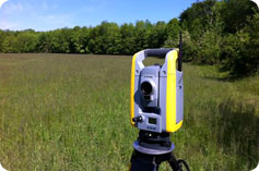
Unlike the surveyors of old, the modern day surveyor is aided by electronic equipment, computers, and better record-keeping to achieve accuracy unparalleled in history. In the United States there are millions of people, each having many basic needs that involve land. No one can accurately predict the problems of the distant future, but some of the needs can be anticipated and prepared for accordingly. Certain needs are obvious; our population has expanded and more efficient use of our land must be made. As the costs of land spiral upward, the delineation of property lines has become more critical. New divisions of land will continue to be made each day, and the ancient surveys will have to be retraced accurately.
References Curtis Maitland Brown & the late Windfield H. Eldridge,
"Evidence and Procedures for Boundary Location",
John Wiley & Sons, Inc. , New York 1962


